19/02/2025
The joint effort of researchers at VITO and Inflights already show seeds of a fruitful collaboration between research and industry. The first milestone of their roadmap to deliver integrated visual communication tools to characterise PV panels remotely is to establish a common working environment and a handbook for their Drone Inspection Application Program Interface (API).
The handbook is confidential and has already been delivered at the end of 2024. It defines not only the drone inspection workflow, with detailed information on the integrated backend communication channels between VITO and Inflights, but also the region-specific operating restrictions for drones.
A drone inspection operation built with real information
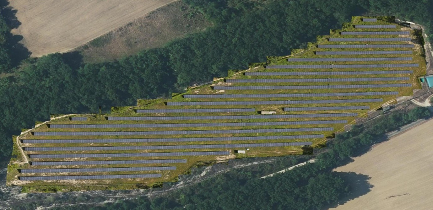
Unlike most of the innovative applications, the drone inspection has already tested various API components against data from one of ENGIE-LAB’s PV-panel field in France.
The definition of the drone inspection workflow will be validated for the first time in a drone test acquisition campaign this summer. In reality, the workflow will undergo several updates, waiting to be improved continuously with information shared by the other project partners in charge of the supply and characterisation of second life PV panels.
The final version of the API components and the deployment of the generic API for the use of local drone operators is expected by the end of 2026. In the meantime, the research team has scheduled a second flight campaign, which will include also an update of the API. To enable its adoption, researchers have already foreseen to build the API in compliance with the European National Aviation Authority (EASA) regulations.
The drone inspection outlines the assessment process for PV panels, which will provide two types of information: high-resolution visual (RGB) and thermal (IR) imagery which will determine a quality label for each PV panel. Also, the drone imagery can be reconstructed to a single overview image.

Overview orthomosaic of the ENGIE-LAB PV-panel field
How will this work in reality? For every identified panel, state-of-the-art (SoA) Artificial Intelligence (AI) and Machine Learning (ML) models analyse these images to detect potential anomalies. These potential anomalies are a priori determined in a complementary work package responsible for the characterisation of 2nd PV panels and quality control handbook. By running the drone inspection in two rounds within a span of one year, the final result will also indicate changes occurring at the level of each PV panel. Finally, the module will feature also a Geographical Information System (GIS) – based online platform, which will enable users to visualize and interact with the results of the processed inspection data.
Beyond the comfort that the process might inspire, the drone inspection has the leverage of accessing hard to reach locations and reducing overall operational costs.
In the SOLMATE project, the drone inspection results will assess the PV panels degradation status, enabling a first classification either for reuse or for recycling. After the drone ‘screening’, a completely autonomous robot tailored for solar farms will dismantle and sort these PV panels.
© visual: ENGIE-LAB